
Here is a run through on how I use my IPhone and the different apps that I use for gravin.
App # 1: MAPS (Comes standard with the IPhone.)
 |
| This is my home screen. |
Next, I search for cemeteries in the town I will be passing. Here is an example. I searched "Cemeteries in Rogers, AR".

All the red pins are different cemeteries in the area. If you touch the red dot the cemetery name will pop up. I have found that several times they have left one or two out. So if you are looking for a specific one then type the name of the cemetery in and it should show up.

If you would rather see them in list form you can get that too. Touch the curled page in the lower right corner.
This page shows up.

Select "List" and now you have a list.

Next to the of the cemetery name, on both the map or the list page, there is a blue arrow, touch that and you can get the listed info for that cemetery. This one includes the phone number, address and web site.

If you would like directions to that specific cemetery then select "Directions To Here". You will get this screen:

Select "Route" and it will take you there from your current location. And they are nice enough to even give you the distance and time it will take you to get there from where you are.

Now it's up to you to follow the purple line and you will make it. As you travel along the purple line the flashing blue dot will keep track of where you are at on it. I have noticed that even when I am in areas with no signal the blue dot still keeps track. Not sure how that works but its pretty cool that it does. And of course you can zoom in and out on the map to get closer looks at street names.
Helpful tip: I like to use the drop pins. I generally visit numerous cemeteries in one trip so to keep track of the locations I visited I use a drop pin. That way after I return home and realize I forgot to photograph the cemetery sign (I generally photo the signs after each cemetery so that it marks the dividing point in my photos.) I can pull out my phone and see which one I forgot. To place a pin you hold your finger on the screen and the pin will appear then you move it to where you want it placed and remove your finger. The pin will remain until you delete it, even if you change directions.
 |
| I drop them directly on top of the red ones. |
The drop pin can also help with the location. If you are unsure of which town the cemetery is in the drop pin will show you an address with the town's name.
*******************
App # 2: Notes
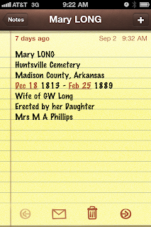
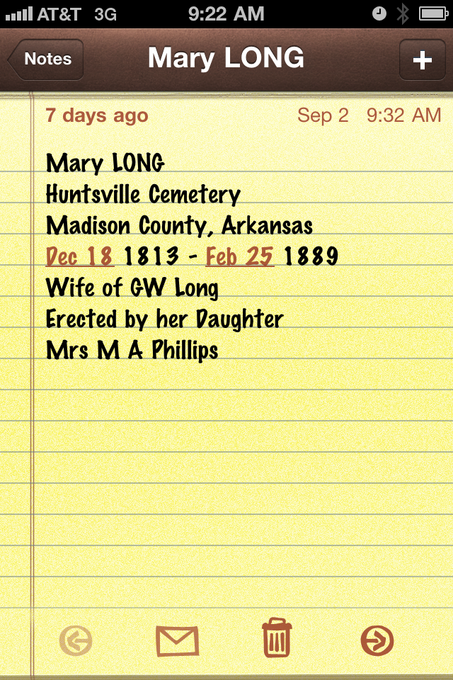
I keep my phone in my pocket while I am out in the cemetery. (You never know when you might need it.) It has replaced my pen and paper. I like to use it to make notes of the hard to read stones. Like so:
Then when I'm done I can email them to myself and have them on my computer when I start transcribing my work.
I also like to to use the notes app for keeping track of stones I want to find when I am in certain cemeteries.

I keep my phone in my pocket while I am out in the cemetery. (You never know when you might need it.) It has replaced my pen and paper. I like to use it to make notes of the hard to read stones. Like so:
I also like to to use the notes app for keeping track of stones I want to find when I am in certain cemeteries.

So there it all is, clear as mud now? I hope it will help you with your use of the IPhone while gravin. If you have any other useful tips please let me know.
Have fun and be safe while your out gravin.
No comments:
Post a Comment